

|
|
On Friday Sept 16th 2011 UKASF had issued a severe convective forecast for N. Ireland for a threat of severe wind gusts, hail up to 2cm in diameter and tornadoes due to a high shear environment associated with 500 CAPE in a very dynamic set-up with good lapse rates and forcing. The consensus was that the W to E passage of an occluded front during the morning would provide the first risk followed by the post-frontal airmass with troughs during the afternoon where there would be a continued risk of heavy showers and scattered thunderstorms with an ongoing chance of tornadoes. I woke that morning to the sound of very heavy rain which I knew would be the occluded front passing over so I turned on my computer to have a quick check on what was happening. The Met Office radar showed an impressive scene with intense radar echoes running along much of the entire front from N. Ireland then curving south towards the Republic. The red colour - which indicates near torrential rainfall - had just moved past my location and now was dominating the E portion of the country. Red echoes can indicate areas of embedded convective cells within frontal systems so if you see this kind of echo in a persistent manner over several radar updates you can be sure there is a storm cell hiding within all that frontal cloud and rain invisible to the naked eye, these are the areas to watch, especially if they show signs of bowing or features like hooks which can indicate major rotation and locations where severe weather is taking place.
I followed the radar image across the border and down into the Republic and was immediately drawn to a very complex region of red echoes SE of the border near the E coast of the country, I actually said out loud to myself that there could be a tornado in that. Soon after I checked the weather forums and suddenly a post appeared reporting a tornado/waterspout within Co. Louth in Clogherhead at 11.45 BST. The observer saw the tornado pass through his property then move out into the Irish Sea where he saw its spray bowl on the surface of the water, the report was backed up by radar however there were no images or video taken due to the sudden nature of the event. This was the second tornado in Ireland during 2011 with the previous event being a damaging tornado in Eglinton, Co. Derry. The frontal system continued moving E into mainland Britain with more interesting radar features which kept other storm chasers busy however back here it was a return to sunshine and blue skies.
I was interested in the unstable airmass behind which would provide a great deal more visibility for chasing. During the afternoon there wasn't really much happening in the N as most of the showers where located in the Republic with storms not far from Dublin. The latest radar showed two showers/cells moving towards Lough Neagh from the SW with the N cell making a bee line for the NW corner of the lough so I decided to make a play on that despite the sferics showing no electrical activity at all. I invited my Sister to come along and together we went on a local chase to Ballyronan Marina, when we arrived it was rather disappointing with no real convection in sight which was a big let down however I decided to meet the radar target rather than have it meet me so I advanced further taking the back roads to Magherafelt then onto the main carriageway with the intention of heading home. We intercepted the cell and punched through its core which was fun due to its intense rainfall rate however there was nothing else on offer other than low level black clouds which looked menacing to the untrained eye but really were rather lame because the cell was too soft and lacked any structure at all so its bark was worse than its bite and with no thunder I decided to head N back home.
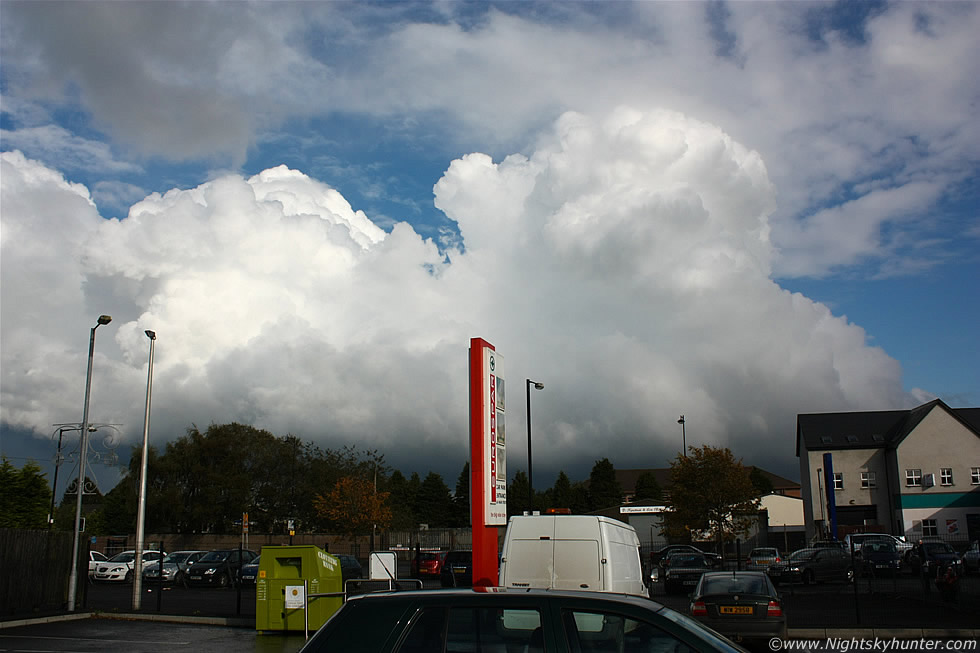 |
Interesting developments began to reveal themselves after 16.30 after seeing nothing of interest all day. I was parked outside the local Eurospar waiting on my Sister when I saw this line of convection suddenly shoot up over the countryside to the E of Maghera, above is the wide angle view taken while leaning on the roof of my car looking E as the line slowly crept from R to L outside of town. The cumulus growth didn't look too inspiring on the leading edge (L) however the rear of the line was a very different story with that single updraught going up at high speed with vigorous intent.
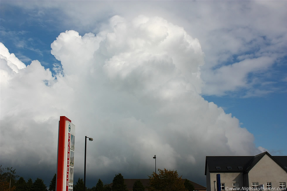 |
This was the view at 32mm, that updraught tower was actually expanding rapidly with wonderful billowing motion to the cauliflower top visible in the viewfinder as the tower exploded into life. This was looking really good and I began to feel anxious because the base of the line was blocked by buildings which meant I could be missing a nice sunlit funnel cloud. My Sister arrived and I pointed out the updraught to her and she was actually impressed and stood studying it for a minute before we got back in the car and went on another local chase to the Maghera countryside where I parked and watched the towers crossing the roads and fields as they moved N looking very dramatic with dark precip and scud tags low to the ground, I went back home and decided to wait for dinner and to kill time I checked the internet again. The radar showed a line of light blue echoes from the above cumulus train and further behind it to the SW was a group of showers with blue and green echoes which looked uninteresting, they would be arriving here soon so I decided to stay home as this was as good a place as any. I was quite certain the day was over for me as time was marching on and I would be soon loosing solar heating and CAPE from this area so I forgot all about storms and spent my time working on other things.
 |
17.00 BST. I was in my room replying to emails when I heard an almighty downpour outside, I immediately opened my window to watch and my Sister did like wise, this rainfall was torrential in nature and without a doubt from a convective origin so I had a look at the radar which informed me that a very large cell was currently moving over the town with a large red echo with another cell further behind to the SW of the first with a similar radar appearance. I watched the heavy precip for a while then soon heard a train of thunder booms one after the other in the distance followed soon after by another angry chorus of thunder, a quick check on the net showed these to be c-g lightning strikes to my SW. The intense precip seemed to last a long time so I kept alternating between watching the skies and comparing that with the online radar. I find it quite exciting when under the precip core of a thunderstorm because you never know what photogenic wonders might be waiting behind the cell when it moves through.
Rain (precip) is good for lightning and precip curtain structure and for enjoying hail - this part of the cell is called outflow and is often the leading edge and central feature of a typical thunderstorm cell. My favourite location is at the rear of the storm - this area is known as the inflow region or flanking area and it is here where the cell 'breaths' in its supply of warm moist air to keep itself alive, if this part of the cell is surrounded by a clearing sky then the cell doesn't have to compete with other showers in the area and therefore has the potential - assuming other parameters are in place - to have a greater life and have a healthy environment to grow stronger and hence increasing the chances of seeing a funnel cloud or tornado under the rain free base (RFB). This region is also the most photogenic providing a host of interesting structures such as a flanking line, updraught towers, anvils, mammatus formations or rainbows lit by a low evening sun which can produce wonderful scenes. This is why I love waiting for a cell to move through because I never know for sure what will be in store.
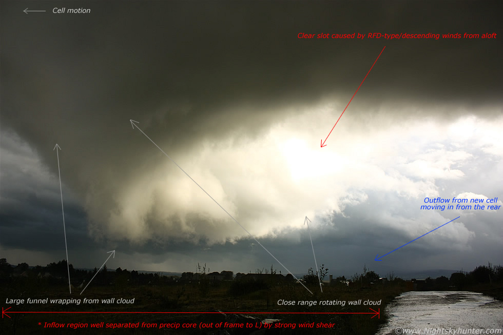
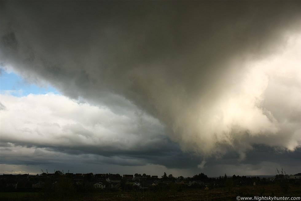
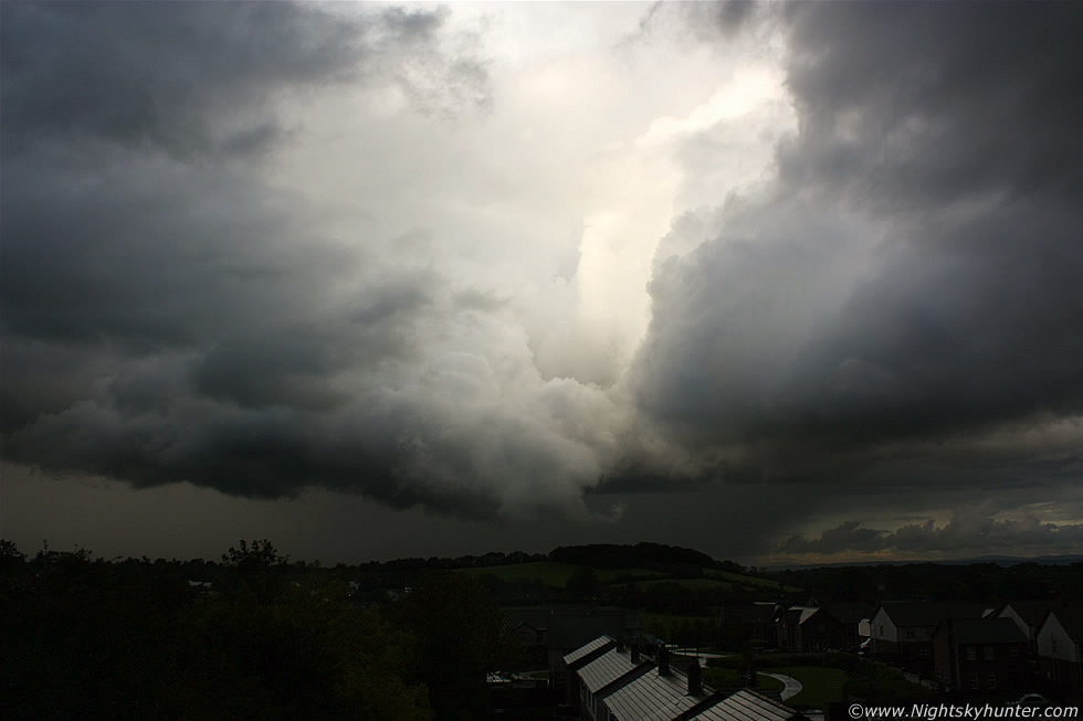
17.44 BST. I saw a strange looking cloud formation becoming visible through the rain and I could tell from it's appearance and movement that something significant was going on so I rushed downstairs, grabbed my camera and jacket, then ran outside, my car was away at this time so I had to go out on foot to get a better view. Fortunately I have a great location on a developing site on high ground close to my home which provided me with a splendid view. I got soaked as I ran through that precip core with eyes stinging and as I arrived at my location I was delighted to see that the precip had moved on past me and I was now standing looking at the inflow region of the storm cell. The above image was what greeted me and within sec's I realised I was looking at major activity so I took this image and annotated the features to describe what I perceived to be happening. The image faces S to SE with the clouds slowly moving from R to L and towards me at the same time. On view is a massive wall cloud - the largest I have ever seen - the wall cloud is the entire dark and white substantial looking cloud formation in the image with an obvious clear slot cutting through the lowering due to descending winds from aloft similar to an RFD-type feature (rear flank down draught). The entire wall cloud was rotating with strong inflow/rising motion and on its leading side (L) was a large funnel wrapping up. The precip core and inflow region where extremely well separated by wind shear to the point were the precip core can't be seen in the image, in reality it was well outside of frame to the LHS. I have also marked on the image the precip core/outflow from the other cell behind the main cell moving in behind it from the S.
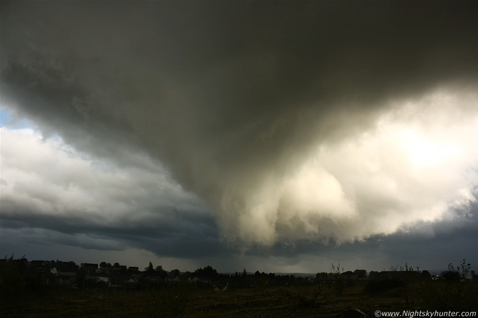 |
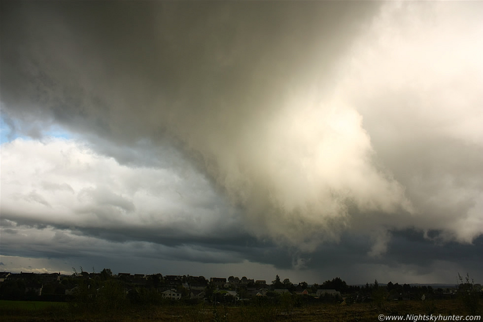
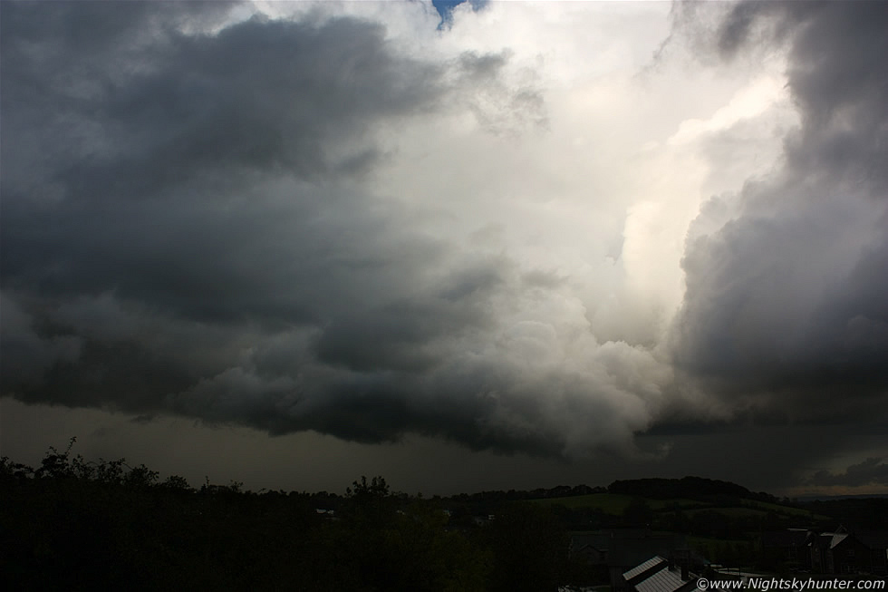
17.44 BST. The huge wall cloud had produced this big funnel straight in front of me!. The entire area from the bottom of the funnel to the top of the image was all rotating, including the other white part of the lowering to the lower R. This is a wide angle 18mm frame so this feature was taking up a very large portion of sky. I could see unreal anti-clock wise rotation along the middle and upper sections of the wall cloud and further rotation - albeit slower - at the lower most portion of the funnel. The motion was R to L and towards me and near the zenith I could see the dark clouds in a very agitated state performing fast motions which I can only describe as a waterfall moving in reverse accompanied by rolling forms. The entire visual scene was utterly brilliant and for all the world it looked like a tornadic funnel about to touch down in the area where I live. At this time the wall cloud and funnel was at very close range and I suspected it was between me and the houses of Crewe Drive in the distance which would have placed it almost directly over the large football pitch belonging to St. Patrick's College which meant the funnel was within 100m of my position.
 |
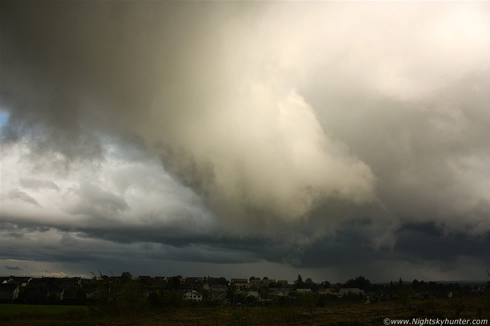
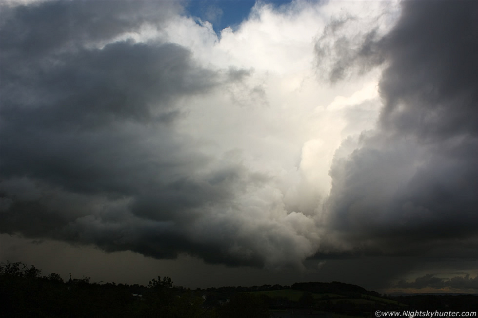
17.45 BST. Same scene except the region of interest was even closer to me as it rotated across the sky combined with a forward R to L motion. The lower part of the funnel relaxed a little at this point and became a little more ragged however the rotating motion of the upper funnel-wall cloud interface became even more spectacular to the point were I was cursing out loud while my hands shook with the adrenaline pumping through me which made it even more difficult to take images. I would have liked these images to have been sharper however my shaking hands and the shutter speed I chose (500/sec) meant that the images came out a little soft despite the IS enabled.
 |
17.45 BST. Huge drum-shaped funnel wrapping up. I wish I could find words to describe the motions I was observing higher up in the darker region. I was astonished how close this was to the ground and it seemed anything was possible after the tornado from earlier this morning, the beast churned around merrily as I wrestled to control my adrenaline and keep shooting with the camera. This was without question the closest I have come to catching a tornado this year and yet another example to add to the growing list of exceptional rotation events which have been happening in the Maghera-Glenshane Pass area during 2011. I have seen more rotating storm lowerings and funnels this year than on any other year since I started chasing and because of this I strongly feel that a notable tornado event is more than likely in this location in the near future.
 |
17.46 BST. The tubular shape to the broad funnel is quite obvious however it's not very smooth and as striking as more typical funnels, the reason for this was that the rotation at lower levels was slower in comparison to the upper regions so it didn't have that tight look to it. The other reason why it looks so ragged is because it is extremely close to the camera, many funnels up close look less neat in comparison to their appearance at a distance when they have that more stream-lined profile.
 |
17.47 BST. Now facing E as I pan the camera to track the area of interest. It doesn't get any closer than this - big funnel to the RHS and so close that I felt I could have thrown a stone at it, had this been an actual tornado with surface contact I would have been in trouble. Again this is at 18mm wide angle and if you compare it with the fourth image from the top you can see that the condensation funnel is more slanted at an angle due to inflow air causing the lowering to lift into a horizontal configuration, at this moment it was in the process of doing that. Things were getting even more interesting because not only was the funnel rotating but also a new area of dramatic rotation and lifting motion had begun ahead of the funnel to the upper L of the image where dark scud tags could be seen spinning with chaotic motion so from here on I was getting treated to two areas of thrilling rotation as the cell continued moving N.
The lowering then moved directly over the estate where I live and I watched in amazement as both areas rotated directly over the path I had ran across earlier when I had left home then proceeded to move over the rooftops sporting two areas of rotation and as I watched I saw several scuddy vortices getting spun up at irregular intervals. This was quite sobering because had there been better atmospheric conditions this day then this could have been a tornado going directly through the estate causing damage to structures and perhaps even lives, and to think that my house could have been one of those affected which was quite shocking.
17.54 BST. The cloud cover overhead broke allowing me tantalizing glimpses revealing the top of the cell, on view where three huge updraught towers and a fuzzy anvil top to the R of the towers all illuminated bright white by sunlight shinning in through that welcome crack in the clouds, it was a dramatic and stunning sight. The cell had passed over a populated area then back over the fields to the N of Maghera near the Coleraine Road. The rear of the cell looked very impressive and photogenic however from my vantage point a large portion of it was blocked by trees, power lines, and a hill, further more I couldn't see the base of the storm anymore so that was something I had to change because that double lowering was still rotating with intent. There was a steep grassy hill nearby which would provide me with the perfect view so I ran up it through trees as branches scratched at my face, I then navigated a trench and made it onto the growing slope at the bottom of the hill which was covered in thick wet mud thanks to the earlier passage of the storm's precip core.
The entire ground looked like that scene from Predator when Arnie was laying flat in the mud near the end. I ran, slipped and fell - not once - but twice onto the ground landing on my forearm and my camera hit the ground with a thump, I almost broke my arm and camera - twice!. I eventually made it to the top of the hill panting for breath and covered in mud just as precip began to fall on me again from the southern cell which had now moved into the area. The above image is facing N to NE showing the rear of the storm with dramatic high contrast clouds on view with precip core in the distance. At the centre, above the small forest, is the funnel I had been shooting now in a horizontal configuration with wisps of cloud wrapped around it.
 |
17.55 BST. These images faithfully show just how dramatic these storm clouds looked at the time. You can see how solid the cloud structure was with beefy updraught towers visible along the entire flanking area of the storm, the rest of the cell extended out of frame to the L.
 |
17.55 BST. That dark region to the immediate L of the white lowering was also rotating while to the far L towards the NW I saw a brute of a wall cloud (the second from the same cell) over the Glenshane Pass, it was huge and very low to the ground with the same vertical lifting and rotating motion as the first wall cloud displayed, I could see vortices spinning up on several positions pendant from this dramatic feature.
 |
17.55 BST. The cell was far enough away to fit in a little blue sky with the tops of the updraught tower and anvil now in view. The same funnel from the start of this report can still be seen near image centre. At this moment I could see three different regions of rapid rotation along the back of the cell which was amazing to watch. I soon lost these areas behind a curtain of precip when the southern cell arrived so I returned back home managing to fall a third time on the mud as I made my way back down the hill, when I arrived inside I checked the clock and noted that I had been watching major rotation for a 20 min period, to get this all happening near my home yet again is not only remarkable but also underscores the significance of this area for vortex formation. I sense that the time is coming close when I will catch my first tornado on camera and I have a feeling it's going to be sooner rather than later!. Thanks very much for reading.
Martin McKenna